De wapens achter de blauwe ladder
The Coats of arms behind the blue ladder
Maassluis ligt aan het einde van een rivier die water uit Duitsland en België afvoert naar de Noordzee. Maar 2x op een dag wordt het hoog water op zee en dan stroomt er zeewater de rivier óp. Van Hoek van Holland tot voorbij Rotterdam is die verhoging van het rivierwater merkbaar. Eeuwenlang was er gevaar van overstroming bij stormachtige wind uit het (noord-)westen. Dan was er ‘springvloed’. Er kwam dan veel meer zeewater de rivier op en dat stroomde over het land. Oogsten werden weggespoeld, huizen verzwolgen en mensen verdronken. Zo’n 850 jaar geleden is daarom een 40 km lange zeedijk langs de rivier aangelegd om overstromingen te voorkomen. Maassluis ligt aan deze dijk.
U staat hier bij de Monsterse sluis. Volgens de overlevering werd aan deze sluis de stad Maassluis gesticht. In 1343 stonden hier twee hutjes van riet en leem. Langzaam groeide de stad hier omheen. De Hoogstraat, waarin de sluis is opgenomen, ligt op de Maasdijk. Deze zeedijk heeft nog steeds een waterkerende functie. De sluisdeuren zijn daarom extra zwaar uitgevoerd, aan beide kanten van de dijk.
Eeuwenlang al wordt in Nederland het waterbeheer uitgevoerd door waterschappen. Die leggen dijken, sloten en sluizen aan en zorgen voor veilige waterstanden in de polders. In onze regio heet het waterschap Hoogheemraadschap Delfland.
Om het regenwater en het grondwater uit de polders af te voeren (spuien) waren vlieten gegraven. De Monsterse sluis verbindt de Noordvliet met de haven van Maassluis en was bedoeld als spuisluis. De eerste echte sluis op deze plek werd in 1602 gebouwd op kosten van het bestuur van Monster. In 1889 werd de sluis omgebouwd tot schutsluis, met name om de tuinders van het Westland met hun agrarische producten een vaarroute naar de haven te bieden.
De sluizen moesten op aanwijzing van het Hoogheemraadschap betaald worden door ambachten (nu noemen we dat gemeentes). De ambachten Monster en Wateringen hebben ieder een vliet aangelegd tot in Maassluis en ieder een sluis in de Maasdijk, de Wateringse sluis en de Monsterse sluis.
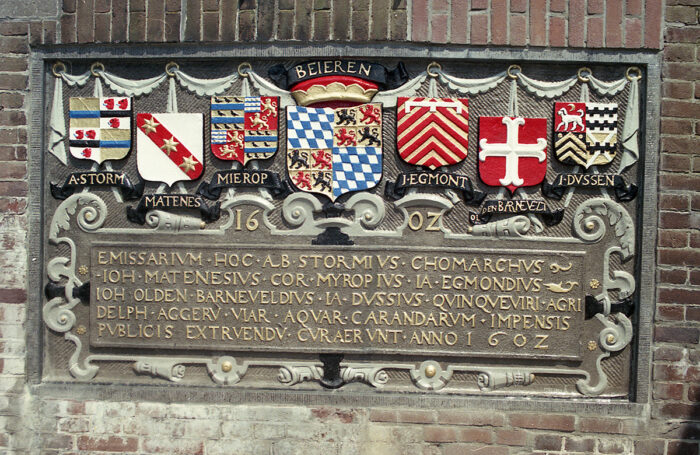
Op de Monsterse sluis is in 1602 een tableau aangebracht. Op dit tableau staan de wapenschilden van de toenmalige dijkgraaf en heemraden (de voorzitter en het bestuur) van Delfland.
In het midden is te zien het wapen van het Hoogheemraadschap Delfland zelf. Aan de linker- en rechterzijde daarvan de wapenschilden van de families van de heemraden. Had elke familie toen een wapenschild? Nee hoor, alleen families van hoge stand. Dat kwam zo.
Lang geleden kwamen tijdens de kruistochten of oorlog zware, gesloten helmen in gebruik. Om in de strijd te zien wie vriend en wie vijand was moest elke ridder zijn eigen teken op het wapenschild afbeelden. Omdat zonen steeds meer het wapen van hun vader gingen gebruiken ontstond het familiewapen. Later gingen ook steden, gilden en belangrijke burgers wapenschilden gebruiken. Zoals de heemraden dus.
De heemraad was in die tijd een groep mensen die uit de lokale bevolking werd gekozen. Zij functioneerden als raadsman van het heim (grond). De heemraden van toen waren niet zo democratisch als nu. Boeren en burgers mochten zich dan wel aansluiten maar de macht lag toch vooral bij de adel en de landsheer. Daar werden de functies en het geld verdeeld. Toch was het ook in die tijd van belang om besluiten gezamenlijk te nemen en samen te werken. In geval van nood werkte de burgers en de adel samen om het water tegen te houden.
Meer wapenschilden van heemraden van Delfland in Maassluis zijn te zien boven de deur van het Delflandhuis, Hoogstraat 11 en op de muur van de Wateringse sluis, Stadhuiskade.
++++++++++++++++++++
COATS OF ARMS AT THE LOCK
Maassluis is located at the end of a river that drains water from Germany and Belgium to the North Sea. Twice a day, however, it gets high tide at sea and then seawater flows up the river. The increase in river water is noticeable from Hoek van Holland to beyond Rotterdam. For centuries there was a danger of flooding in stormy winds from the (north) west, which would lead to a spring tide. Much more seawater then came up the river and flowed over the land. Crops were washed away, houses engulfed and people drowned. About 850 years ago, a 40 km long seawall was built along the river to prevent flooding. Maassluis is located on and around this dike, locally called the Maasdijk.
You are here at the Monsterse Sluis (Monster Lock). According to tradition, the city of Maassluis was founded at this site. In 1343 there were two huts made of reed and clay. Slowly the city grew around this. The Hoogstraat (‘elevated street’), in which the lock is included, is located on the Maasdijk. This seawall still has a flood defense function. The lock gates are therefore extra heavy, on both sides of the dike. Water management in the Netherlands has been carried out by water boards for centuries. They build dikes, ditches and locks and ensure safe water levels in the polders. In our region, the water board is called Hoogheemraadschap Delfland.
Canals were dug to drain rainwater and groundwater from the polders. The Monsterse Sluis connects the canal Noordvliet with the port of Maassluis and was intended as a discharge sluice. The first edition was a mere outlet with a slide-block in it. The first real sluice on this site was built in 1602 at the expense of the Monster board. In 1889 the sluice was converted into a lock, in particular to offer the market gardeners of the Westland with their agricultural products a sailing route to the port.
At the direction of the Water Board of Delfland, the sluices had to be paid for by municipalities in the hinterland. The Monster and Wateringen municipalities have each constructed a canal to Maassluis and a sluice in the Maasdijk, the Wateringen Sluice and the Monsterse Sluice (now Monster Lock).
A tableau was added to the Monsterse lock in 1602. This tableau shows the coats of arms of the then chairman and board members of Delfland. In the middle is the coat of arms of the Delfland Water Board itself. On the left and right side of it the coats of arms of the families of the board members. Did every family have a coat of arms back then? Nope, only high-class families.
This is how it grew. Long ago, heavy, closed helmets came into use during the Crusades or wars. In order to see who was friend and who was foe in battle, each knight had to depict his own character on the coat of arms. Because sons increasingly started to use their father’s coat of arms, the family coat of arms was created. Later, cities, guilds and important citizens also started to use coats of arms. So like the Delfland board members.
At that time, the Water Board was a group of people chosen from the local population. They functioned as counselors for the heem (homeland). The board members then were not as democratic as they are now. Farmers and citizens were allowed to join, but power lay mainly with the nobility and the lord of the land. There the functions and the money were divided. Even then, it was important to take decisions together and to work together. In an emergency, the citizens and the nobility worked together to stop the water.
More coats of arms of the board members of Delfland can be seen in Maassluis above the door of the Delfland House, Hoogstraat 11 and on the wall of the Wateringen Sluice, Stadhuiskade.
De wapens achter de blauwe ladder
The Coats of arms behind the blue ladder